
Landscape Ecology - Lecture Notes

Landscape Modeling
I. Why Are
Models Necessary in Landscape Ecology?
Practical concerns:
- - Difficulties for experimental or observational studies at
larger scales
- - Lack of replicates in landscape ecological studies
- - Interactions between spatial and temporal dynamics
- - Multiple scale dynamics and hierarchical linkages
Simulation modeling, as a key tool for integrating
information and testing hypotheses, has been of great importance
in understanding complex dynamics of ecosystems. Also,
simulation modeling is the only means for extrapolating
ecological relationships among research sites with different
environmental driving functions and across a range of spatial
and temporal scales over which controlling factors may vary
significantly.
Simulation
modeling
is increasingly conducted with use of GIS and remotely sensed
data. For example, GIS packages like GRASS and ARC/INFO have
been used to derive input data sets and to display outputs for
the simulation models by overlaying different layers of data
(e.g., meteorology, soils, vegetation, topography), which are in
turn based on remotely sensed information.
II. Some Basic
Concepts in Ecological Modeling
III. Types of Landscape
Models
- There are various ways to classify landscape models,
depending on criteria of relevance. Here are some examples
which should help understand the variety of and relationship
among spatial models.
- It must be noted that many if not most spatial models
actually may simultaneously belong to two or more categories,
or fall somewhere between the extreme types.
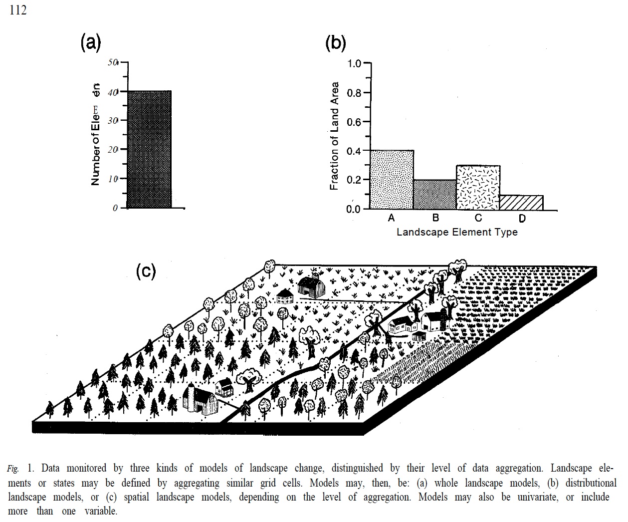
A. Based on the degree of spatial detail:
- - Non-spatial models (Little use in landscape ecology)
- - Quasi-spatial or distribution models (Widely used)
- - Spatially explicit models (Widely used and
representative of landscape models)
Spatial models are those that explicitly
consider the spatial location of, and spatial relationship
among, the entities and processes that are modeled.
B. Based on mathematical characteristics:
- - Analytical vs. simulation spatial models
- - Continuous vs. discrete spatial models (in both space and
time)
- - Differential vs. difference equation models (continuity vs
discreteness)
- - Stochastic (or probabilistic) vs. deterministic spatial
models
- - Matrix models vs. dynamic system models
C. Based on the degree of mechanistic detail:
- - Phenomenological spatial models
- - Mechanistic (or process-based) spatial models
D. Based on the way of spatial data being handled:
- - Raster-based (or grid-based) models
- - Vector-based models (e.g., neighborhood models,
patch-based models
E. Based on entities and processes modeled:
- - Spatial metapopulation models
- - Spatial disturbance models (e.g., fire, patch dynamics,
disease spread)
- - Spatial ecosystem models (e.g., biogeochemical or nutrient
dynamics models, hydrological models)
- - Spatial vegetation dynamic models (e.g., succession models
for forests, grasslands, etc.)
- - Spatial models of land use change

IV. Examples of
Landscape Models
1. Transition Probability Models
2. Cellular
Automata Models
- A cellular automaton (CA) is an array of cells that
interact with one another locally according to some neighborhood
rules.
- Cellular automata provide a framework for a large class of
discrete models with homogeneous interactions. They are
characterized by the following fundamental properties:
- They consist of a regular discrete lattice of cells.
- The dynamics of the system takes place in discrete time
steps.
- Each cell is characterized by a finite set of states.
- Each cell evolves according to some local rules which depend
only on the state of the cell and a finite number of
neighboring cells.
- The neighborhood relation is local and uniform.
- Some History (Slides from Atkinson, Sawada and Gajewski 1998)
- Cellular automata have been used in landscape modeling in
which landscapes are represented by fixed arrays of cells
(lattices or grids).
- Each cell in the lattice denotes an area of the land
surface, and the states associated with each cell correspond
to certain ecological features (land use and land cover types,
vegetation types, successional stages, population densities,
etc.).
- The CA approach has been used to model fire spread,
population dynamics, vegetation dynamics, land use change, and
other landscape phenomena.
- Pixel-based satellite remote sensing data and quadrat-based
field data can be easily used with CA models.
3. Process-Based Landscape Models
- Spatially Explicit Ecosystem Models: Ecosystem
models "implanted" into a spatial grid (or lattice)
4. Individual-Based Models (IBMs)
Individual-based models (IBMs) are those that
mimic the structure and dynamics of ecological systems based
on information at the level of individuals of
organisms. There are two groups can be distinguished:
- individual-based distribution
models and
- individual-based configuration
models.
The former group lumps individuals together
according to some common characteristic, while the latter
keeps track of all individuals in a spatially explicit
fashion and thus relies heavily on computer
simulation. In general, IBMs are important for linking
processes operating at different organizational scales
around the level of individuals, which is a central piece of
the problem of scaling in ecology.
Back to Dr. J. Wu's Landscape Ecology
Homepage


